Healthy Food Access Data Library Project

Collect and analyze data about the food system in San Diego county. The San Diego Food System Alliance’s Healthy Food Access Working Group is developing an indicator library to analyze food access issues, and we need your help to locate datasets, wrangle them into useable shape, and create visualizations. The work is similar to the topics … Read more

SDSU Datathon

Solve Social Problems for $2,700 in Prizes The San Diego Regional Data Library, the SDSU Society for Statisticians and Actuaries and Teradata are organizing a data analysis contest to aid nonprofits, journalists and government agencies in making better use of data, develop a broader regional capacity for data analysis, and introduce students interested in data … Read more

Student Data Analysis Contest

Give your nonprofit, agency or news organization valuable data-driven insights by sponsoring a project at our student data analysis contest.  The San Diego Regional Data Library, the SDSU Society for Statisticians and Actuaries and Teradata are organizing a data analysis contest to aid nonprofits, journalists and government agencies in making better use of data, develop a broader regional … Read more

Drugs and Alcohol in Downtown and East Villiage

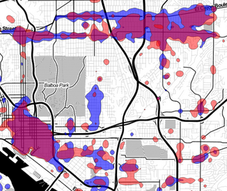
For the last few months, a team of geography students at SDSU have been working with the crime data provided by the Library, producing analyses and visualizations of the data. Elias Issa has been looking at Drugs and Alcohol violations in Downtown San Diego and East Village. He writes: The Hot Spot tool calculates the  Gi* … Read more

Population Density Maps

Here is some  eye candy, a population density map of Pacific Beach and surrounding neighborhoods. This map was created with a lot of Python code, using the 2010 census shapefiles for census blocks, setting a value for each block as the population of the block divided by the area of the block, and rasterizing all … Read more

What Is Crime Analysis?

On Wednesday March 6 we’ll kick off our Crime Data Analysis project, and before then, it may be worth asking “Why are a bunch of amateurs attempting what the police should be doing? ” The answer is that police departments analyze crime to catch criminals, and the Data Library analyzes crime to help residents understand their … Read more

Fight Crime with Data

Citizens of any skill level are invited to help us analyze crime in San Diego neighborhoods. Use your knowledge of the community or technical skill to create maps, discover anomalies, and better understand the causes and solutions to crime in San Diego.  Come to the Kickoff meeting by signing up at Meetup.com Crime is always … Read more